
How to Travel the Silk Road by Train: Routes, Stops and Tips
PAGE
By Finixio Digital
The Silk Road was never one road. It was a network of trade routes that carried silk, spices, paper and ideas between China and the Mediterranean for well over a thousand years. Caravans crossed deserts, skirted mountain ranges and stopped at oasis towns that grew rich on the traffic.
Today you can follow much of the Chinese section by rail. The railway runs alongside the old caravan route for hundreds of miles, through the same passes and past the same oasis towns.
This guide explains how to travel the Silk Road by train, what the main routes cover, and what you need to plan before you go.
Two different ways to do it
Before choosing a route, decide which style of travel suits you. The two options are very different.
Regular trains. You buy individual tickets, travel between cities on scheduled services, and book your own hotels and guides. This is the cheapest option and gives you full freedom. It also takes real effort. Ticket booking in China requires advance planning, sleeper berths sell out fast in summer, and English is limited once you leave the main cities.
Private tourist trains. You book one package. The train carries only holiday guests, you sleep on board in a private cabin, and excursions, guides and transfers are all arranged. It costs much more and the route is fixed, but you never repack and you never queue for a ticket.
Most first time visitors to the region, and most travellers short on time, choose the second option. Independent travellers with several weeks and some patience often prefer the first.
The main route and its stops
The classic Chinese Silk Road runs roughly west from central China toward the Central Asian border. These are the places most itineraries are built around.
Xi'an. The eastern starting point and the ancient capital of Chang'an. Famous for the Terracotta Army and the old city walls.
Lanzhou. A city on the Yellow River and the gateway into the Hexi Corridor.
Xining. The capital of Qinghai province and the usual access point for the Tibetan plateau. Sits at around 2,275 metres.
Qinghai Lake. China's largest lake, salty rather than fresh, ringed by grassland and mountains at roughly 3,200 metres.
Zhangye and Jiayuguan. Zhangye is known for its striped rainbow rock formations. Jiayuguan holds the western fort that marks the end of the Great Wall.
Dunhuang. The most important stop on the route. Home to the Mogao Caves, a complex of Buddhist grottoes carved over roughly a thousand years, plus the Singing Sand Mountain dunes and Crescent Moon Spring.
Turpan. A desert basin that sits below sea level. Very hot in summer, known for grapes and ancient underground irrigation channels.
Urumqi and Kashgar. The far west. Kashgar is closer to Central Asia than to eastern China in both distance and atmosphere, and its Sunday market is the most famous in the region.
You do not need to see all of these on one trip. Most journeys pick a section.
Choosing your route
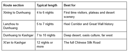
If this is your first visit, the Xining to Dunhuang section is the easiest place to start. It packs plateau lakes, salt flats, deserts and the Mogao Caves into a short trip, and both ends have airports with good domestic connections.
The private Silk Road train journey operated in the region runs several route options across these sections, including both directions of the Xining to Dunhuang line and longer itineraries into southern Xinjiang.
The best time to travel
Season matters more here than in most parts of China, because the route crosses both high plateau and open desert.
Spring, April to May. Cool and dry with few crowds. Sandstorms are possible in the desert sections. Nights are still cold on the plateau.
Summer, June to August. Peak season. The grassland is green and the rapeseed fields around Qinghai Lake flower in July. Turpan and the low desert become extremely hot, often above 40°C. Book early.
Autumn, September to October. The best overall window for most travellers. Comfortable temperatures, clear skies, strong light for photography, and autumn colour in the poplar groves.
Winter, November to March. Very cold and many sites operate reduced hours. Some tourist trains do not run this section at all. The upside is empty caves and dunes.
If you can only pick one month, September is usually the safest choice.
How many days you need
4 to 5 days. One short section only, such as the Xining to Dunhuang route.
7 to 9 days. A comfortable trip covering plateau, corridor and the Dunhuang area.
12 days or more. Needed if you want to include Xinjiang and Kashgar.
Do not underestimate the distances. This region is enormous, and the gaps between major sites are measured in hundreds of kilometres.
What to pack
The main packing challenge is temperature range. It can be near freezing at dawn on the plateau and very hot in the desert the same afternoon.
Layers rather than heavy clothing, including a warm outer layer even in summer
A wide brimmed hat, sunglasses and high factor sun cream, since the sun is intense at altitude
Comfortable walking shoes with closed toes for sand
A scarf or buff for dusty conditions
Lip balm and moisturiser, because the air is extremely dry
A power bank, as charging points can be limited on excursions
Modest clothing for religious sites, covering shoulders and knees
If you are travelling on a private train, laundry is usually included, so you can pack lighter than the trip length suggests.
Practical tips
Altitude. Xining and Qinghai Lake sit high enough that some people feel mild effects such as headache or breathlessness. Take the first day slowly, drink plenty of water and avoid alcohol early in the trip. Speak to your doctor first if you have heart or lung conditions.
Photography. Ask before photographing people, especially at markets and religious sites. Some sites, including parts of the Mogao Caves, do not allow photography at all.
Cash and payment. Mobile payment dominates in China. Set this up before arrival if you can, and carry some cash for small purchases in remote areas.
Book ahead. Mogao Caves visits are limited by daily quota, and summer sleeper tickets sell out weeks in advance. Private train departures often sell out months ahead.
Time zone. The whole country runs on Beijing time, so in the far west the sun rises and sets several hours later than the clock suggests. Local life adjusts accordingly.
Common questions
Do I need a visa? Most nationalities need a visa for China. Check current requirements before booking, as rules change.
Is the region safe for travellers? The route is generally straightforward for tourists. Some western areas have additional checkpoints and registration procedures. A guide or tour operator handles these for you.
Can I do the trip independently? Yes, using scheduled trains and local guides. It costs far less and takes more planning.
Does the railway continue into Central Asia? Yes. Rail routes continue into Kazakhstan and beyond, though these usually require separate arrangements and additional visas.
What is the single best stop? Most travellers say Dunhuang. The Mogao Caves are one of the great cultural sites in Asia, and the dunes are a short drive from the town.
Final thoughts
Travelling the Silk Road by train works because the railway follows the same logic the caravans did. It runs where water and passes allow people to move, so the landscape unfolds in the same order it always has.
Whether you do it independently or on a private train, give yourself more time than the map suggests, travel in shoulder season if you can, and treat Dunhuang as the anchor of the trip rather than one stop among many.
HOW DO YOU FEEL ABOUT FASHION?
COMMENT OR TAKE OUR PAGE READER SURVEY
Featured




Deep clean, seal, and protect your tile & grout in Oceanside, CA. Bring the original shine back to your floors. Request a quote today!