
How Better Site Capture Improves Coastal Project Accuracy
PAGE
By PAGE Editor
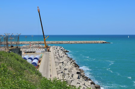
I reviewed a berth expansion job on the NSW coast last year. The drawings showed pile locations for a wharf built in the 1990s, and they were wrong by nearly 400 millimetres.
No one knew until a crane barge arrived and its spud legs nearly clipped piles below the waterline. The result was two weeks of delay, emergency dive inspections, and a rushed lifting plan.
That problem shows up on coastal jobs more than teams like to admit. Old drawings, patchy seabed data, and mismatched models create rework that burns time and budget.
A better approach is simple. Capture the land, shoreline, and seabed as one scope, then build one model the whole team can trust.
Key Takeaways
The fastest way to lose accuracy is to treat land and water data as separate jobs. That split also slows construction planning, because survey teams then juggle separate access, control, vessels, and safety steps when they need to move gear and crews onto the water quickly.
Capture above and below the waterline before design freeze. One baseline removes guesswork and gives designers real conditions.
Tie all data to GDA2020 and AHD. Shared coordinates stop painful fixes later.
Match the tool to the surface. Use TLS for structures, aerial LiDAR for broad ground, and multibeam sonar for the seabed.
Set quality targets early. Standards such as IHO S-44 help you buy the right survey for the risk.
Measure results with hard numbers. Track clashes, RFIs, vessel hours, and clean handover data.
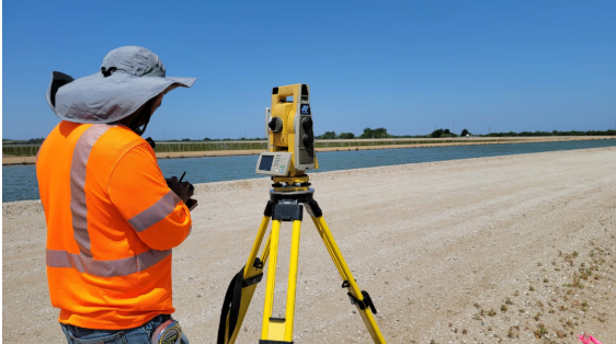
What These Tools Actually Do
These methods create a measurable picture of what is really on site, not what old drawings say is there.
Terrestrial laser scanning, or TLS, uses a tripod scanner to capture millions of points. It is well suited to wharves, abutments, steelwork, and plant rooms where small offsets matter.
Mobile scanning puts the same idea on a vehicle or backpack. It covers corridors and yards faster, though it usually trades a little precision for speed.
Aerial LiDAR and photogrammetry cover larger areas. LiDAR works well through light vegetation, while photogrammetry builds a 3D model from overlapping photos. USGS quality levels are a useful reference for vertical accuracy on airborne work.
Multibeam echo sounders map the seabed with full coverage and are now standard for serious seabed surveying. In very shallow, clear water, bathymetric LiDAR can fill gaps where boats cannot work safely.
QA terms matter. THU and TVU mean horizontal and vertical uncertainty at 95 percent confidence. RMSEz is a vertical accuracy measure for airborne data. IHO S-44 sets survey orders so teams can match quality to project risk.
Three Big Benefits for Complex Sites
Good capture reduces avoidable problems before they move from the model to the site.
Fewer Surprises and Change Orders
Designers can work from ground truth instead of assumptions. When point clouds go into BIM early, clash checks catch misaligned piles, utilities, and access conflicts before drawings are issued. Teams with strong BIM use report fewer errors and less rework.
Safer Planning and Fieldwork
Remote capture keeps people away from edges, ladders, and unnecessary vessel time. Long-range scanners, drones, and better survey planning reduce exposure to weather and vessel movement, which is a practical safety gain, not just a paperwork win.
Clearer Permitting and Resilience Decisions
Accurate shoreline and bathymetric data support dredge volumes, berth clearances, and climate risk reviews. Repeat surveys also show how seabeds shift over time, which helps teams explain clearance margins to regulators and asset owners. This long-term, data-driven mindset aligns with how progressive cities are approaching circular infrastructure planning at a broader scale.
Where to Use Them Across the Project Lifecycle
The best results come when capture is planned at each project gate, not added after a problem appears.
Feasibility: A quick scan and sounding can test access, concept quantities, and hidden constraints before budgets harden.
Reference Design: Build a full land and seabed baseline, and locate utilities to AS5488 QL B where conflicts are likely.
Detailed Design: Tighten tolerances, upgrade key crossings to QL A, and run clash checks against the point cloud.
Construction: Verify barge access, lift paths, temporary works, and berth clearances before the marine plant hire mobilises.
Handover and Operations: Use final as-builts for acceptance, then repeat surveys to track movement, settlement, and shoaling.
How to Track Accuracy and ROI
If you want support for the spend, show what changed after capture became part of delivery.
Rework and Change Orders: Compare current jobs with past jobs. Even one avoided redesign or delayed barge shift can cover a large share of survey cost.
RFIs and Clashes: Count coordination issues by discipline and track how many were closed before site work started.
Time on Water: Log vessel hours for survey and construction. Better data should mean fewer return trips and less exposure.
Data Quality: Report control residuals, achieved uncertainty, coverage percentage, and whether the survey met the specified order.
Datums and Handover: State GDA2020 and AHD clearly, record transformations, and include independent check points in acceptance.
Make Scans and Surveys Work on the Next Job
Start with a small, well-scoped pilot, then turn what works into a standard.
Pilot First: Choose one berth, bridge approach, or shoreline reach. Publish minimum requirements for deliverables, file names, control, and QA.
Choose Suppliers Carefully: Look for proven land and seabed capability, clear uncertainty reporting, clean BIM workflows, documented QA requirements, examples of registered point clouds delivered at project coordinates, and teams that can manage repeat visits without changing methods. If you need support across regions and want matched outputs, as-builts, and field planning nationwide, a professional 3d laser scanning company can simplify procurement.
Assign Ownership: Give one design manager or digital lead control of standards, storage, and coordination.
Keep the Data Usable: Store epochs, transformations, coverage maps, and QA logs in one place so the next team does not start from scratch.
Case Example: Wharf Fender Replacement Done Right
A short survey before design freeze can prevent weeks of downstream disruption.
A port authority planned to replace fenders on an aging wharf. Legacy drawings placed pile lines about 350 millimetres from their true position. An integrated land and seabed survey caught the offset, found submerged debris near the fender pockets, and confirmed utility locations at key crossings. The crane barge spud layout was redesigned in the model before mobilisation, and the team avoided a late redesign that could have cost three weeks.
Conclusion
Accurate projects start with accurate site data.
When one capture plan covers the ground, structures, shoreline, and seabed, teams make better decisions earlier. That means fewer surprises, safer planning, and cleaner handover information. The tools and standards already exist, so the real choice is whether the next job begins with facts or with assumptions.
FAQs
These are the practical questions most teams ask before they commit to a capture program.
What Accuracy Should I Ask For on Land?
Set accuracy by use, not by habit. Ask for millimetre-level work where fit matters, and centimetre-level work for general context. Always request QA evidence, including control residuals and uncertainty reporting.
How Do I Choose Between Multibeam Sonar and Topo Bathy LiDAR?
Use multibeam for most seabed mapping because it gives full coverage and handles turbid water well. Use green laser bathymetric LiDAR in very shallow or clear water where boats cannot work safely. Some sites need both.
Which Australian Datums Should My Team Use?
Use GDA2020 for horizontal control and AHD for vertical control. Note the epoch, record any transformation, and make sure every model uses the same reference.
How Do I Bring Scan Data Into BIM Without Slowing the Model Down?
Import registered point clouds in formats such as E57 or LAS at project coordinates. Model only the elements needed for decisions, and keep the full point cloud as the measured record.
HOW DO YOU FEEL ABOUT FASHION?
COMMENT OR TAKE OUR PAGE READER SURVEY
Featured


Cleaning out a property, tackling a major renovation, or clearing storm debris all have one thing in common: the waste has to go somewhere.